Lao Cai Province
1. Introduction to Lao Cai province
Lao Cai is one of the several provinces situated on the Sino-Vietnamese borderline. It is in the northwestern part of the country. Apart from the Kinh people, the province has several ethnic minority groups including the H'mong, the Tay, the Dao and the Thai peoples.
The name "Lao-Kay" has been used by the French since the colonial era in their writing, pronounced as "Lào Cai" by the Vietnamese. The latter became official usage and spelling after November 1950.
The origin of the province's name is unclear and there are several explanations. The area in the ward of Cốc Lếu was the site of an old commercial district that developed into a market town. Because of this it was called Lão Nhai. After this a new market town was developed and named Tân Nhai. The word Lào Cai is sourced to "Lao Kay" which appeared in 1872; the name of a boat of Jean Dupuis, who led a naval expedition up the Red River. According to Professor Đào Duy Anh, it derives from the word "Lão Nhai". While making maps, the French wrote it as "Lao-Kay" and this word was used by them in documents. When reading, the Vietnamese pronounced it Lào Cai and this has persisted since.
The province is endowed with many places of natural beauty. Visitors to the mountain province may enjoy a rice terraced fields crawling on high mountain slopes in summer. When winter comes European people visiting Lao Cai may feel a bit nostalgia while enjoying picturesque sights of snow-capped mountain peaks. Yet, ones may feel light hearted when the spring comes with many white-flower peach trees in blossom. Then in summer visitors can go to Sapa, the most regionally famous mountain resort town in northern Vietnam.
2. Three Ideal Tourism Destinations for the Summer in Lao Cai
Sapa, Bac Ha and Y Ty that belong to Lao Cai province listed among top tourist attractions for the visitor during the summer.
Sapa – Summer capital
According to the historic documents, in 1903, when the adventurers of Indochina Geography Department explored Sa Pa plateau during their first topographic plotting of the northern area. In 1905, the very first data about the geography, weather and vegetation were collected by French. Thence, Sapa became more and more well-known for its magnificent views, cool and fresh weather that similar to the Europe’s weather in winter. In 1909, a convalescence and medical treatment area was built up. In 1917, a tourism office was founded in Sapa and one year later, the French people started to build up their first villas. In 1920, the railway Ha Noi – Lao Cai was completed and Sapa then was considered of as the summer capital of the North.
At the moment time, several constructions and buildings that were built in 20th century such as Cong Doan hotel, Stone Church or Cat Cat hydroelectric plant are still maintained in good condition. Furthermore, Sapa town has been rebuilt since 1991. Up until now, Sapa has approximately 200 hotels and guest houses as well as several new resort projects that is preparing for operation in order to meet the demand of visitors. Especially after the inauguration of Noi Bai – Lao cai highway lead to the significant increase in the number of tourist visiting Sapa.
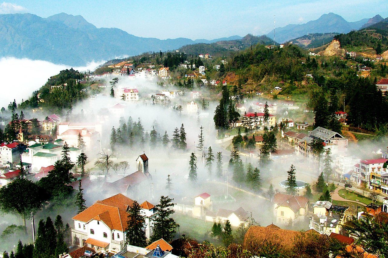
Sapa - The valley city in the mist - Photo: sinhcafehanoi.com.vn
scenery of the Sapa region in large part reflects the relationship between the ethnic minority people and nature. This is seen especially in the paddy fields carpeting the rolling lower slopes of the Hoang Lien Mountains. The impressive physical landscape, which underlies this, has resulted from the work of the elements over thousands of years, wearing away the underlying rock.
Most tourists agree that it would be regretful if the leisure and relaxation time in cool and fresh weather is not accompanied by visiting trips to Sapa’s prideful natural beauty spots, such as Ham Rong Mountain, Silver Waterfall, Rattan Bridge, Bamboo Forest and Ta Phin Cave. The town is also the starting point for many mountain climbers and scientists who would like to discover the Fansipan Mount, the highest mountain in Vietnam with 3,143 m height. Can you imagine that Hoang Lien Mountain Range is called “the Alps of the North Sea area” since Fansipan Mount also marks its greatest height among others in the Indochina Peninsula as well. The pyramid-shaped mountain is covered with clouds all the year round. On top of the mountain is filled with frequent below zero temperature, especially at high altitudes.
On approaching the town, the very first thing tourists may find is the detached wooden mansions and villas perched on top or side of the hills, behind thick pine forests, hided by fog in the morning. Old and new villas with red roofs now appear and then disappear in the green rows of pomu trees, bringing in the beauty of European towns.
Bac Ha – The White Plateau
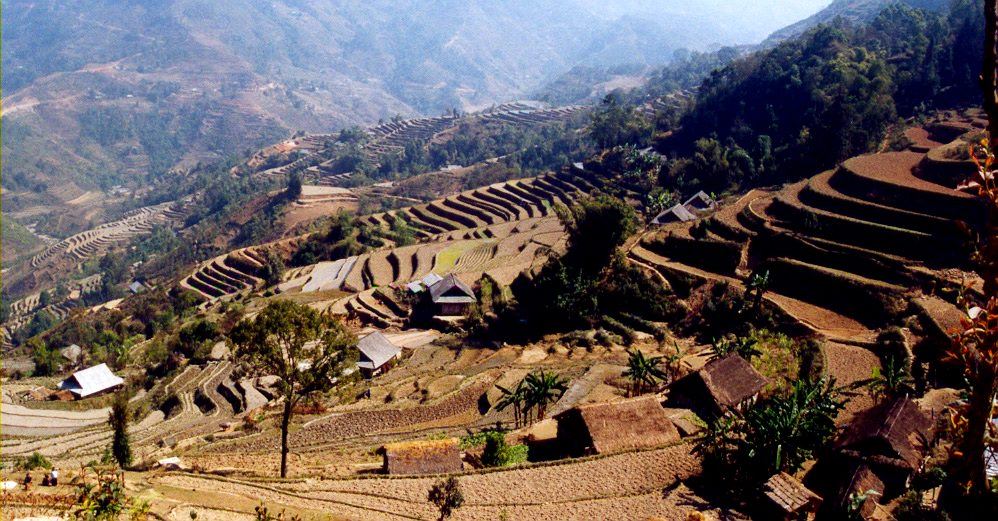
The terraced fields in Bac Ha - Photo: trungthanhphoto.wordpress.com
Bac Ha is among the well-known beauty spots in Lao Cai province, north-west Vietnam, and 100km east of Sapa. The Bac Ha plateau lies at an altitude of about 1200 above sea level. Therefore, climate of Bac Ha is similar to Sapa with cool and fresh weather for most of the year.
An urban planning project for Bac Ha tourism industry were announced by Ministry of Construction and local authorities, under which Bac Ha plateau will become an attractive and original resort in the northern mountainous of Vietnam. This is the result of cooperation between Lao Cai People’s Committee and experts from France’s Aquitaine region.
Visiting Bac Ha will brings to visitors an opportunity to enjoy the beauty of the mountainous area which is called with the name White Plateau., especially in spring when the plum flowers bloom. In addition, tourists can also explore the culture of different local minor communities in their traditional markets like Coc Ly market, Can cau market …
Y Ty – The second Sapa
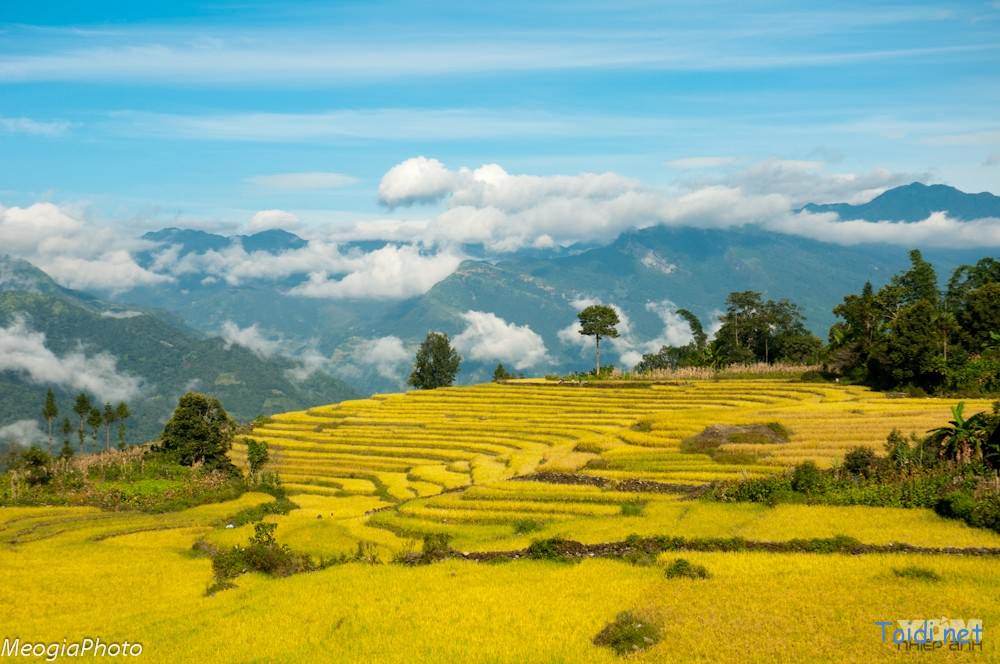
The mysterious beauty of Y Ty - Photo: toidi.net
Y Ty commune is located west of Bat Xat district and lies at the height of 1.600m above sea level. Therefore, all year round the village is covered by dense white clouds. In winter, visitors can see the rare phenomenon of snow and ice which cover all the roads, villages and mountains here.
In recent years, the route to Y Ty has become easier due to the operation of the tarred road from Trinh Tuong, goes through the jungle. As the result, the number of visitors are increasing significantly, especially young travelers and photographers.
Coming to Y Ty, visitors are amazed at the beautiful and mysterious of the jungle which is the natural habitat of several kinds of ancient trees, colorful flowers. In addition, travelers can visit the weekly market of Ha Nhi people, Hmong people and Dzao people for exploring their traditional culture.
If you are planning to visit Lao Cai, please do not hesitate to contact us! Email us: info@ahomevietnam.com